


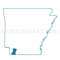
Stamps Ward 1, Lafayette County, Arkansas
About
Outline

Summary
| Unique Area Identifier | 527024 |
| Name | Stamps Ward 1 |
| County | Lafayette County |
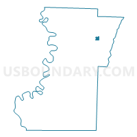
| State | Arkansas |
| Area (square miles) | 0.61 |
| Land Area (square miles) | 0.60 |
| Water Area (square miles) | 0.00 |
| % of Land Area | 99.28 |
| % of Water Area | 0.72 |
| Latitude of the Internal Point | 33.36422710 |
| Longtitude of the Internal Point | -93.48418020 |
Maps

Graphs
Select a template below for downloading or customizing gragh for Stamps Ward 1, Lafayette County, Arkansas


Neighbors
Neighoring Voting District (by Name) Neighboring Voting District on the Map
- Center Voting District, Lafayette County, AR
- Sardis Voting District, Lafayette County, AR
- Stamps Ward 1 PCT 2, Lafayette County, AR
- Stamps Ward 2, Lafayette County, AR